
Toolbar: ‘Create a new globe’ > New Map | New Globe
Smartpad: Properties Tab > Options and Formatting
Scalable maps are based on areas instead of a single dot by using GIS-technology (Geographic Information Systems - technology).
 file format which requires a special license or custom Analytics integration by DocuPhase Professional Services. For additional information on Scalable Maps, see the topic: Special Custom Contract Options.")
The Scalable map is also used to display data in relation to locations and may contain several layers of information. The further you zoom into a scalable map, the more details will be available to you. If the necessary detail is available, you may zoom a map from the Continent level via Countries, States, Regions, Zip Codes all the way down to street names and house numbers.
The level of detail is determined by the information within the GIS-maps. These maps are available, usually at a cost, from local and international GIS-providers. The mapping between GIS-information and dimension values is regarded as an administrative task and is handled centrally in the Analytics Management Studio as a part of an Analytics LOB-Licensed installation.
In addition to the scalability of these maps, scalable maps also allow component areas of the map such as countries, counties, states, etc. to be displayed as colored areas rather than just colored dots.
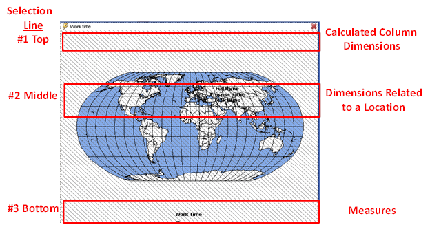
There are three selection lines on the definition stage of a scalable map object. The first one, placed at the top of the map is a selection line for dimensions. This selection line is designed to add dimensions to the Scalable map object’s underlying cross table, with the purpose of making a calculated column. The colors of the table entries in the rightmost (calculated) column are used for coloring the location areas. To learn more about Object calculations, see the Calculation Functions topic.
The second selection line, placed in the middle of the Scalable map window, is a selection line for dimensions which are used to place dimensions related to geographical locations. Any dimension can be placed here, but normally they will have a predefined geographical location.
The last selection line, placed at the bottom of the map, is for measures.
Navigation and Zoom is a little different from the other objects. Use + and – keys or the mouse scroll wheel to zoom in and out according to the current center of the map. Holding the Alt key while zooming makes the increments smaller. To move the center of the map, press and hold down the right mouse button while dragging the center of the map to a new position.
To change the properties of the scalable map, see Formatting Options in the Object Functions topic.